
Lake Jackson
What’s Happening Near Lake Jackson
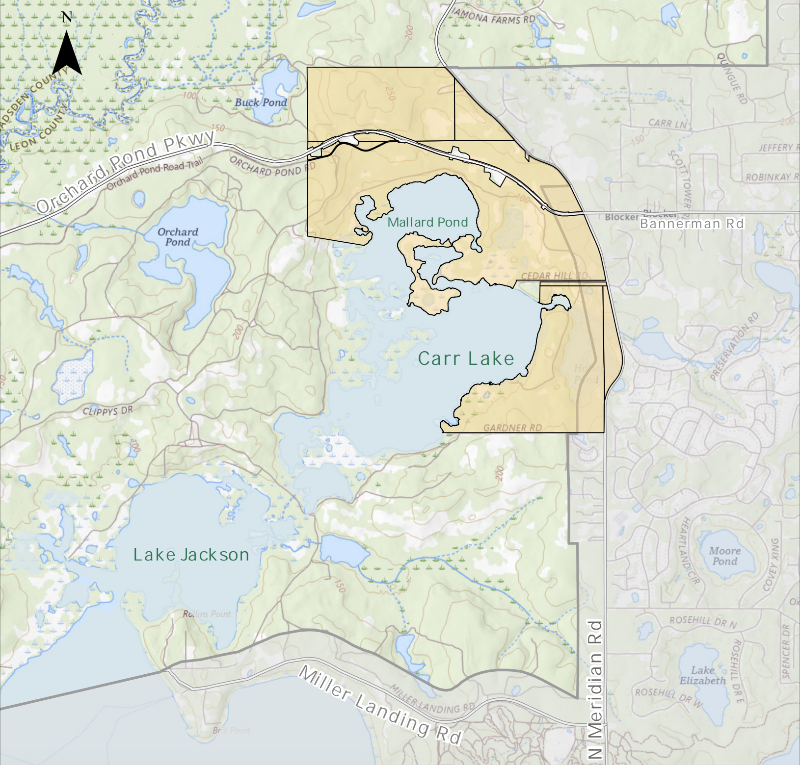
The proposed annexation of approximately 1,742 acres north of Lake Jackson has been withdrawn, but the future of the property remains unresolved. Development at this scale could cost taxpayers hundreds of millions of dollars, significantly increase traffic on Meridian Road, and impact wildlife and natural resources in one of our community’s most environmentally sensitive areas.
Area That Was Proposed for Annexation
Proposed Annexation – 1,742 acres
Urban Service Area
Take A Deeper Dive
Voluntary Annexation Application: VIEW PDF
This was filed by the landowner. The map differs some from the original property that he sought to have included in the Comp Plan. Most notable, is that one of the parcels stretches across Meridian Road at the entrance of Summerbrooke. This small sliver is already included in the Urban Services Area. The importance of this is described in the Annexation section below.
City’s Feasibility Study: VIEW PDF
A decision with consequences lasting decades deserves a thorough analysis. Read the City’s feasibility study for yourself and decide whether less than a page of narrative provides enough information to evaluate the impacts of annexing nearly 1,742 acres.
Interlocal Agreement Between the City and County on Annexation: VIEW PDF
This document explains the County’s role in the annexation process. While the County cannot stop annexation, it can request additional information and studies before the City moves forward. This particularly important given both the City and County share responsibility for Meridian Road and the uncertainty surrounding future funding if the property tax referendum passes in November.
The Scale of the Development
Without a master plan, we don’t know the full scale of what the developer has in mind. However, we do know the landowner sought Comprehensive Plan (Comp Plan) changes for much of this same property in 2025 that offer important clues. Had he been approved, it would have opened the door to urban-scale development that could include thousands of homes, shopping centers, offices, restaurants, and other commercial uses.
Land Use: Rural

Allows Up to
1 House Per 10 Acres
Land Use: Lake Protection

Allows Up to
20 Housing Units Per Acre Per Acre

Allows Up to
20,000 Sq. Ft. of Commercial Space Per Acre
How Big is 1,742 Acres?
More Than
½
the Size of
Southwood
2,900 Acres
Nearly
2x
the Size of
Welaunee
900 Acres
Important Questions Should Be Answered
Before this development is considered, these key questions should be answered:

How Much Will it
Cost Taxpayers?

Can Meridian Road Handle
More Traffic?

How Will This Impact The
Environment?
A Closer Look at the Timeline
Annexation was only the latest attempt to transform more than 1,700 acres of the most environmentally sensitive land near Lake Jackson.
Dec. 2025

The County Said No
The landowner sought to move the property into the Urban Services Area and increase its development potential through a Comprehensive Plan amendment. The County Commission rejected the proposal.
Jan. 2026
New Comp Plan Policy Takes Effect
New Comp Plan policy goes into effect. Now land within the Urban Services Area may NOT remain designated as Rural, requiring a new land use classification if annexed.
May 2026
Annexation Opens the Door
The landowner petitions to annex the property into the City which includes a parcel already located within the Urban Services Area.
Aug. 2026
Annexation Application Withdrawn
The landowner withdrew the annexation request before the City Commission’s public hearing and final vote. The property remains in unincorporated Leon County with its Rural land-use designation intact.
Most Likely Land Use:
Lake Protection – That Sounds Good…Right?
1000 Friends of Florida describes it this way: “Despite its name, the current Lake Protection zoning language focuses on promoting suburban development instead of protecting the lake. The development potential on the parcel will increase dramatically, from up to 170 units under Rural to up to 6,000 units under Lake Protection.”
The Hidden Consequence of Land Use Changes:
Once Granted, Development Rights Are Difficult to Reverse
Under Florida law, once development entitlements are granted, local governments generally cannot reduce them later. As a result, decisions made during the annexation and land use process can have lasting impacts on traffic, infrastructure, taxpayers, and the environment.
Take a Deeper Dive
Public Outcry the First Time This Was Tried
Comp Plan Community Engagement Summary Report: VIEW PDF
Last fall, the City and County held five community meetings to give residents an opportunity to review the proposed Comprehensive Plan maps and ask questions. Residents concerned about the proposed changes near Lake Jackson attended meetings at the Lake Jackson and Bradfordville community centers. According to the Planning Department’s November 18, 2025 summary, more than 90 people attended the two Lake Jackson-area meetings, compared with just 23 attendees at the other three meetings combined. With the exception of four comments, every public comment received focused on concerns or opposition to the proposed changes that would increase the property’s future development potential.
- Overview of Lake Jackson & Bradfordville Community Meetings: Pages 29 & 33
- Major Topics in Written Feedback: Page 35
- Comments: Pages 48-51
Status Report on the Tallahassee-Leon County Comprehensive Plan Land Use and Mobility Element Update: VIEW PDF
At the same November 18 County Commission, the Planning Department presented a status report. In it, they outlined:
- Concerns raised by the public: Pages 4 & 14
- Environemental risks: Page 5
- Traffic issues and called adding capacity impractical: Pages 5-6
- Recommended it be removed from the Urban Services Area and not receive a land use change: Page 8
* Note: This document was included in the County Commission Meeting Packet and as such has page numbers 534-551. The page numbers referenced are where they fall in the attached pdf.
What is the Urban Services Area and what does density mean?
The Urban Services Area (USA) is the area designated for urban growth where public services such as roads, water, sewer, parks, and emergency services are planned to be provided. Land within the USA is generally eligible for more intensive development than land outside it. Density refers to how many homes can be built on a piece of property.
Bottom Line
The annexation may be off the table today, but the future of this land is not settled. Before another proposal moves forward, the public deserves to understand what is being proposed, what it could cost, what could be lost and whether the infrastructure needed to support it can realistically handle the growth.
Sources
- Annexation Map – Created by 1000 Friends of Florida – You can read what they have to say about this issue on their webiste: HERE
- Voluntary Annexation Application – More details can be found under the “Take a Deeper Dive” section located at the bottom of the What’s Happening section above – VIEW PDF
- City’s Feasibility Study – More details can be found under the “Take a Deeper Dive” section located at the bottom of the What’s Happening section above – VIEW PDF
- Interlocal Agreement Between the City and County on Annexation – More details can be found under the “Take a Deeper Dive” section located at the bottom of the What’s Happening section above – VIEW PDF
- Comp Plan Community Engagement Summary Report – More details can be found under the “Take a Deeper Dive” section located at the bottom of the Annexation section above – VIEW PDF
- Public Comment Received About this Property Made During the Comp Plan – Can be found in the “Status Report on the Tallahassee-Leon County Comprehensive Plan Land Use and Mobility Element Update”. More details can be found under the “Take a Deeper Dive” section located at the bottom of the Annexation section above: VIEW PDF